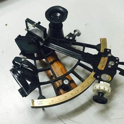
A marine sextant is an essential navigational tool used by sailors and explorers throughout history to measure the angle between two celestial bodies, most commonly the sun and a star. It has been utilized for centuries to help determine latitude and longitude at sea with remarkable accuracy. The use of this instrument requires knowledge of mathematics, astronomy, physics, trigonometry and optics in order to obtain precise readings. This article will provide an overview of what a marine sextant is, its historical significance and current uses as well as instructions on how it works.
Historically, the concept of using angles to calculate distances dates back thousands of years when ancient astronomers developed basic instruments such as astrolabes and quadrants which were able to measure angles up to 90°. Over time these devices evolved into more complex tools like the octant (1730) and then eventually the sextant (1802). Due to their compact size and efficient design, they quickly became popular among naval forces around the world who relied heavily on accurate navigation for safe travel across oceans.
The modern Marine Sextant was invented around 1730 by John Hadley and Thomas Godfrey, who combined principles previously developed by Leonard Digges and Edmund Gunter over 200 years earlier. Since this time, improvements have been made which allow for more accurate readings while making them easier to use. In recent decades they have largely been replaced by electronic navigational systems but remain popular amongst recreational sailors due to their simplicity and accuracy when used properly.
History And Development
The marine sextant is a navigation instrument used to measure the angle between any two objects, typically the horizon and another visible object such as the sun or stars. It was developed in 1730 by John Hadley and Thomas Godfrey, who together invented an improved version of navigational instruments known as octants. The main application of this device was for measuring latitude at sea. As navigation technology advanced during later years, the sextant became more sophisticated with added features such as adjustable mirrors and telescopes that allowed for greater accuracy when taking readings.
Over time, the sextant has been widely adopted by sailors, mariners and other professionals involved in maritime activities due to its reliability and precision when measuring angles from far distances. This ability makes it ideal for use in many areas including celestial navigation, positioning, surveying, geodesy and meteorology. In addition to being utilized for navigation purposes, this instrument can also be employed for scientific research related to celestial bodies’ positions in relation to each other. Today’s modern versions are equipped with digital readouts which allow even greater accuracy than their manual counterparts while still maintaining portability.
Design And Functionality
Having discussed the history and development of marine sextants, it is now time to explore their design and functionality. Marine sextants are precision instruments consisting of several parts that together make up a complex instrument used in navigation at sea. The construction of a marine sextant includes four main components:
- Frame – This is the backbone of the marine sextant’s structure which attaches all its other elements together.
- Index arm – This allows for adjustments when measuring angles during operation.
- Horizon mirror – This reflects light from celestial objects to measure angles precisely.
- Telescope – A telescope magnifies images allowing for more accurate readings when navigating at sea level.

Digital Sextant
The combination of these components enables users to determine angles between two points on earth with great accuracy using principles related to geometry, optics and astronomy such as triangulation and spherical trigonometry. In addition, technical specifications like index error, an arc scale or a Vernier scale enable direct readout of angle measurements needed in navigational calculations onboard ships or vessels out at sea. Thus, taking into account both its design features and operational principles, we can see how a marine sextant works as a tool providing highly precise angular data necessary for safe navigation while travelling across oceans and seas worldwide today.
Uses In Navigation
By using a combination of these measurements, navigators are able to accurately determine their geographical position at sea. The use of a sextant in marine navigation dates back centuries and has become one of the most reliable methods of measuring location during long voyages.
The primary use of a marine sextant is to calculate latitude or longitude coordinates on Earth’s surface. This is achieved through the measurement of angular distances between two points in space – usually a star in relation to the horizon line. Sextants can also be utilized for more specific tasks such as determining altitude levels above sea level; this technique is known as altimetry. Additionally, with sufficient practice, users may employ their device to locate other vessels from considerable distances away; this method is referred to as ‘celestial sighting’ or ‘celestial range-finding’.
Marine sextants have been used successfully since ancient times and remain popular today due to its accuracy even when relying solely on visual data collection: no additional technology is required beyond what comes pre-installed within the device itself. This portability allows them to be applied anywhere around the world where there are visible night skies available for observation – making it an essential tool whenever precise navigational information needs to be obtained quickly and reliably while at sea or in remote areas without access to modern technology.
Accuracy
Accuracy is an important consideration when it comes to marine sextants. A high degree of accuracy allows for more accurate navigation and a safe voyage. The accuracy of the instrument depends on several factors such as:
- Quality of construction
- Precise alignment of the optical components
- Accuracy of the arc graduations
- Reflection characteristics of mirrors or prisms used in the instrument
- Stability over time and temperature variations
Extensive testing has been done to measure, analyze and understand the accuracy of marine sextants. Various tests have been conducted to evaluate various parameters such as index error, dip correction, magnification factor, etc., to provide detailed information about the performance and accuracy level attained by each product design. To ensure that these instruments are tested properly, specialized test machines and software are utilized, which are designed specifically for this purpose. By measuring all relevant parameters according to international standards set forth by governing bodies like IALA (International Association Of Marine Aids To Navigation And Lighthouse Authorities) and ISO (International Organization For Standardization), manufacturers can guarantee the reliability and accuracy of their products before they reach customers. It is essential for these measurements to be taken regularly during production processes in order to maintain quality control levels.
The importance of precision measurement techniques cannot be denied; therefore great attention should always be paid towards ensuring that only certified equipment with proven results are employed when assessing marine sextant accuracy. Furthermore, periodic maintenance should also be carried out in order to keep any degradation caused due ageing at minimum level thus allowing users to enjoy optimal performance throughout its lifetime.
Read more: Parts of a ship
Conclusion
The marine sextant is a precise and reliable tool that has been used for centuries to help navigators find their way across the seas. Its design, functionality and accuracy are key components in ensuring successful navigation and have made it an essential part of seafaring activities. It is also one of the few instruments which can be used accurately without any external reference points.
The modern sextant consists of two main parts: a frame and an index arm. The frame holds mirrors or prisms within its structure while the index arm allows for measurement readings on angles ranging from 0° to 120° with precision up to ¼ minute angle. This instrument, when combined with tables showing sunrise/sunset times, star positions and other astronomical data enables mariners to determine latitude and longitude coordinates during voyages.
In addition, this versatile device can be used in conjunction with other tools such as gyrocompass, chronometer and radar systems to provide even more accurate navigational information. As technology advances, so too does our understanding of how the marine sextant works and its uses in navigation become clearer. In conclusion, the marine sextant remains a vital component of maritime travel, providing sailors with invaluable information about their position at sea.


